P
Loading blog...
Loading blog...
Research without spatial context is often research that misses the geography of the problem. Here is what GIS adds and how to integrate it.
Kwame Mensah
May 12, 2026•4 min read
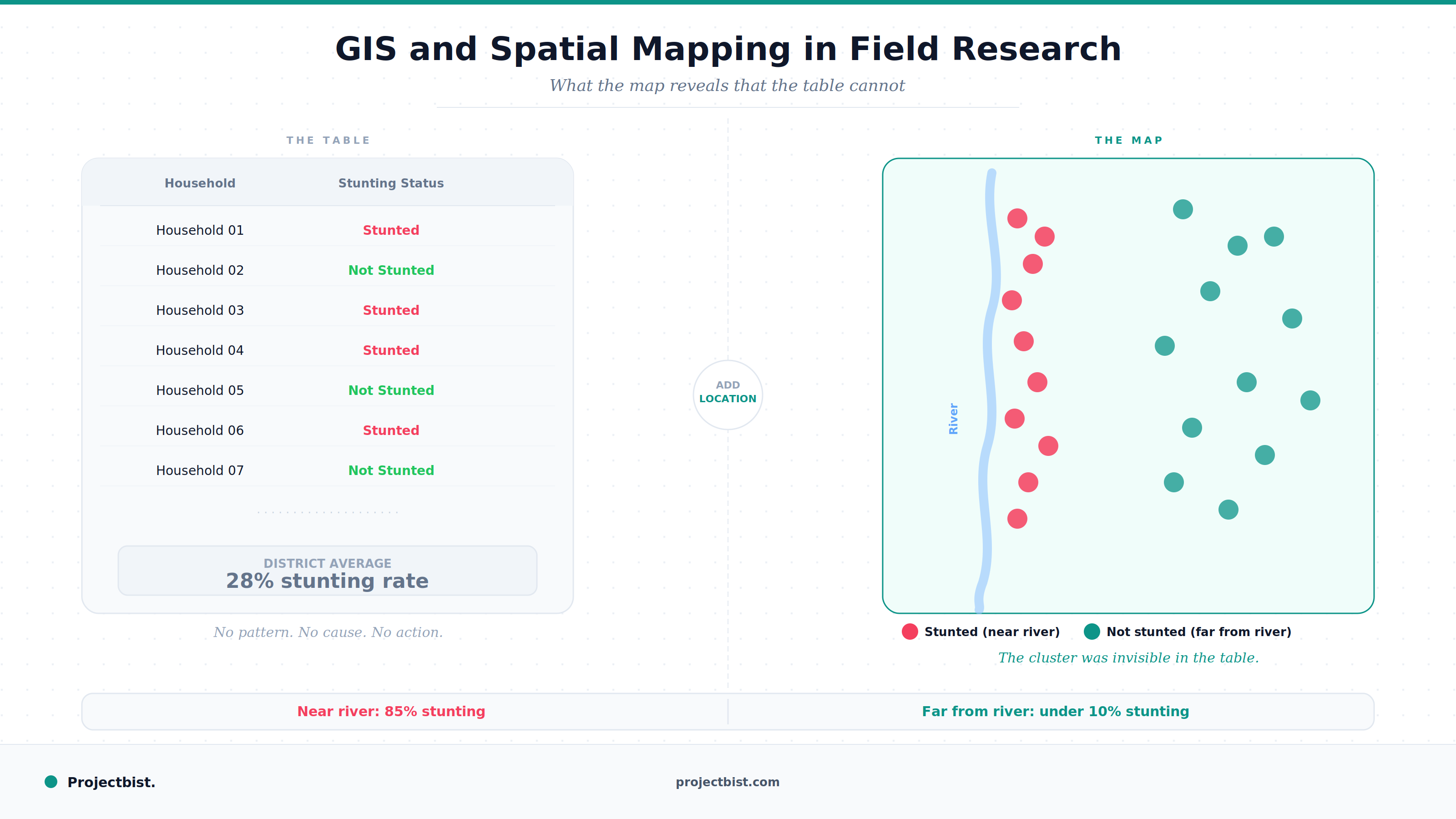
A nutrition survey finds that child stunting rates in a district average 28 percent. That number is important. But when you map the GPS coordinates of each surveyed household against their stunting status, a pattern emerges: nearly all the high-stunting households cluster within two kilometers of a specific river. The households furthest from that river have stunting rates under 10 percent.
That spatial finding, invisible in tabular data, identifies a geographic determinant of the problem that changes the entire program design response. That is what GIS adds to field research.
Geographic Information Systems (GIS) refer to tools and methods for capturing, storing, analyzing, and visualizing data that has a location component. In field research, the most common GIS application is attaching GPS coordinates to survey responses and using those coordinates to analyze how outcomes vary by location, proximity to infrastructure, distance from services, or population density.
GIS in research is not just about making maps. It is about using spatial relationships as analytical variables. Distance from a health facility is a spatial variable. Whether a household falls within or outside a program's catchment area is a spatial variable. These variables can be included in regression models, used to define sampling strata, or visualized to communicate findings more intuitively than tables allow.
Most professional field surveys now collect GPS coordinates as standard practice through CAPI platforms. KoboToolbox, SurveyCTO, and ODK all support GPS field types that automatically record the device's location at the time of submission. This creates a spatial record for every interview without the enumerator needing to do anything beyond enabling location services on the device.
For household surveys, GPS is collected at the household level. For facility surveys, it is collected at the facility. For observation-based studies, it is collected at each observation point.
QGIS is the leading free, open-source desktop GIS platform. It allows users to visualize and analyze spatial data, overlay maps from different sources, and export publication-ready maps. For researchers without a dedicated GIS specialist, QGIS has extensive documentation and community tutorials and is significantly more accessible than its commercial alternatives.
The commercial industry standard. More powerful for complex spatial analysis and better supported for enterprise environments. Used by major development organizations and government statistical offices. The cost is a barrier for smaller research teams, though ArcGIS Online and ArcGIS Pro offer scaled pricing for academic and non-profit contexts.
A cloud-based platform for large-scale environmental and geospatial analysis. Particularly useful for research that incorporates satellite imagery, land use classification, vegetation indices, or climate data alongside survey data.
GPS coordinates collected in the field are privacy-sensitive. Any dataset that includes household GPS locations can be used to identify and locate individual households, which creates serious risks for studies in conflict-affected areas or for vulnerable populations. Data security and access controls must be designed with this in mind.
Most spatial analysis beyond basic visualization requires at least intermediate GIS skills. If your team does not have them, plan to either bring in a specialist or build in training time before analysis begins. Using GIS tools without understanding what the analysis is doing produces maps that look credible but may be analytically misleading.
Newsletter
Personalize your updates! Subscribe to ProjectBist's Newsletter and choose from the following categories.
Ethnographic Research: How to Study Culture and Community by Being Present in Ways Other Methods Cannot
Survey Translation and Back-Translation: How to Ensure Your Instrument Means the Same Thing in Every Language
How to Build a Research Firm From Scratch: What the First Three Years Actually Require